Picture 1 of 1
Stock photo

Picture 1 of 1
Stock photo
United States, Great Lakes by National Geographic Staff and National Geographic Maps - Adventure (2022, Sheet Map, Folded)

Rarewaves USA CA (56819)
98.6% positive feedback
Price:
C $29.44
(inclusive of GST)
ApproximatelyS$ 27.50
+ $4.35 shipping
Returns:
30 days return. Buyer pays for return shipping. If you use an eBay shipping label, it will be deducted from your refund amount.
Condition:
Oops! Looks like we're having trouble connecting to our server.
Refresh your browser window to try again.
About this product
Product Identifiers
PublisherNational Geographic Maps
ISBN-101566957184
ISBN-139781566957182
eBay Product ID (ePID)237765308
Product Key Features
Edition2022
Book TitleUnited States, Great Lakes
Number of Pages1 Pages
LanguageEnglish
TopicUnited States / MidWest / East North Central (Il, in, Mi, Oh, Wi), Special Interest / Adventure, Maps & Road Atlases (See Also Reference / Atlases, Gazetteers & Maps)
Publication Year2022
IllustratorYes
GenreTravel
AuthorNational Geographic Staff, National Geographic Maps-Adventure
Book SeriesNational Geographic Adventure Map Ser.
FormatSheet Map, Folded
Dimensions
Item Weight3 Oz
Item Length4.3 in
Item Width9.3 in
Additional Product Features
Intended AudienceTrade
Series Volume Number3124
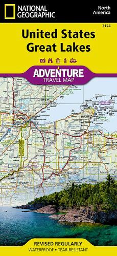
Synopsis- Waterproof - Tear-Resistant - Travel Map There are few nations as vast and spectacularly diverse as the United States of America. From the Atlantic to the Pacific, "America the Beautiful" offers boundless destinations and experiences for travelers seeking outdoor adventures, small town delights, or the excitement of urban culture. The United States Great Lakes Adventure Map will guide you to the five Great Lakes of Superior, Michigan, Huron, Erie, and Ontario. This region of the country has used the Great Lakes as a pathway for exploration, trade and recreation for hundreds of years and these traditions still thrive as witnessed by the cities and towns that border the Great Lakes. The states of Minnesota, Wisconsin, Illinois, Michigan, Indiana, Ohio, Pennsylvania, and New York all benefit from their contact with the largest freshwater lake system on Earth. The map includes the cities of Duluth, Milwaukee, Chicago, Detroit, Toledo, Cleveland, Erie, and Buffalo on the American side with Toronto, Kingston, and Windsor on the Canadian side, and the breathtaking Niagara Falls in between. There is simply no better map for exploring the states bordering the Great Lakes. National Geographic's US Adventure Maps provide the most authoritative and convenient travel maps available to plan and guide your USA Adventure. Each map delivers the perfect combination of detail and perspective, highlighting travel routes, topography, and points of interest for those venturing beyond the city centers. Whether you're on a classic American road trip or planning a grand tour to visit several cities or national parks, these maps offer the ultimate geographic resource as only National Geographic can provide. Every Adventure Map is printed on durable synthetic paper, making them waterproof, tear-resistant and tough -- capable of withstanding the rigors of international travel. Map Scale = 1:1,300,000 Sheet Size = 25.5" x 37.75" Folded Size = 4.25" x 9.25", There are few nations as vast and spectacularly diverse as the United States of America. From the Atlantic to the Pacific, 'America the Beautiful' offers boundless destinations and experiences for travelers seeking outdoor adventures, small town delights, or the excitement of urban culture. The United States Great Lakes Adventure Map will guide you to the five Great Lakes of Superior, Michigan, Huron, Erie, and Ontario. This region of the country has used the Great Lakes as a pathway for exploration, trade and recreation for hundreds of years and these traditions still thrive as witnessed by the cities and towns that border the Great Lakes. The states of Minnesota, Wisconsin, Illinois, Michigan, Indiana, Ohio, Pennsylvania, and New York all benefit from their contact with the largest freshwater lake system on Earth. The map includes the cities of Duluth, Milwaukee, Chicago, Detroit, Toledo, Cleveland, Erie, and Buffalo on the American side with Toronto, Kingston, and Windsor on the Canadian side, and the breathtaking Niagara Falls in between. There is simply no better map for exploring the states bordering the Great Lakes. National Geographic's US Adventure Maps provide the most authoritative and convenient travel maps available to plan and guide your USA Adventure. Each map delivers the perfect combination of detail and perspective, highlighting travel routes, topography, and points of interest for those venturing beyond the city centers. Whether you're on a classic American road trip or planning a grand tour to visit several cities or national parks, these maps offer the ultimate geographic resource as only National Geographic can provide. Every Adventure Map is printed on durable synthetic paper, making them waterproof, tear-resistant and tough - capable of withstanding the rigors of international travel.
All listings for this product


Be the first to write a review


