Picture 1 of 1
Stock photo

Picture 1 of 1
Stock photo

National Geographic Reference Map Ser.: Americas - National Geographic by National Geographic Maps - Reference and National Geographic Maps Staff (2022, Map, Other)

CE Showroom and Atlantis Showroom (80833)
99.6% positive feedback
Price:
US $49.17
(inclusive of GST)
ApproximatelyS$ 63.37
+ $23.37 shipping
Returns:
30 days return. Buyer pays for return shipping. If you use an eBay shipping label, it will be deducted from your refund amount.
Condition:
Oops! Looks like we're having trouble connecting to our server.
Refresh your browser window to try again.
About this product
Product Identifiers
PublisherNational Geographic Maps
ISBN-100792250214
ISBN-139780792250210
eBay Product ID (ePID)204335193
Product Key Features
Number of Pages1 Pages
LanguageEnglish
Publication NameAmericas-National Geographic
Publication Year2022
SubjectSouth America / General, Earth Sciences / Geography, Atlases, Gazetteers & Maps (See Also Travel / Maps & Road Atlases), Travel, Reference, Science
TypeMap
AuthorNational Geographic Maps-Reference, National Geographic Maps Staff
SeriesNational Geographic Reference Map Ser.
FormatMap, Other
Dimensions
Item Weight7.2 Oz
Item Length25.2 in
Item Width2.2 in
Additional Product Features
Edition Number2022
Intended AudienceTrade
TitleLeadingThe
IllustratedYes
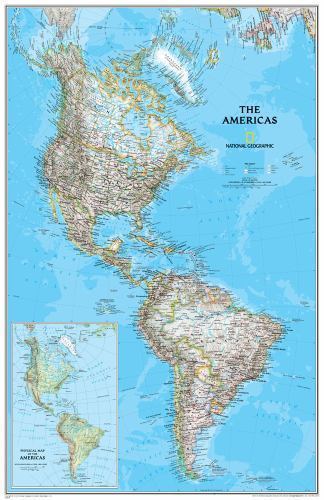
SynopsisNational Geographic's Classic style political wall map of The Americas features a bright color palette with blue oceans and the continents' terrain detailed in stunning shaded relief that has been a hallmark of National Geographic wall maps for over 75 years. A physical map of The Americas is provided as an inset. This map includes thousands of place names, accurate political boundaries, archeological sites, and major infrastructure networks such as roads, canals, ferry routes, railroads, and airports. Coastal bathymetry is shown with depth curves and soundings, and symbolism for water features and other land forms provides greater detail of the nature of the geography. The map is encapsulated in heavy-duty 1.6 mil laminate which makes the paper much more durable and resistant to the swelling and shrinking caused by changes in humidity. Laminated maps can be framed without the need for glass, so the frames can be much lighter and less expensive. Map Scale = 1:19,100,000 Sheet Size = 23.75" x 36.5", National Geographic's Classic style political wall map of The Americas features a bright color palette with blue oceans and the continents' terrain detailed in stunning shaded relief that has been a hallmark of National Geographic wall maps for over 75 years. A physical map of The Americas is provided as an inset. This map includes thousands of place names, accurate political boundaries, archeological sites, and major infrastructure networks such as roads, canals, ferry routes, railroads, and airports. Coastal bathymetry is shown with depth curves and soundings, and symbolism for water features and other land forms provides greater detail of the nature of the geography. The map is encapsulated in heavy-duty 1.6 mil laminate which makes the paper much more durable and resistant to the swelling and shrinking caused by changes in humidity. Laminated maps can be framed without the need for glass, so the fames can be much lighter and less expensive. Map Scale = 1:19,100,000 Sheet Size = 23.75" x 36.5", National Geographic Wall Maps offer a special glimpse into current and historical events, and they inform about the world and environment. Offered in a variety of styles and formats, these maps are excellent reference tools and a perfect addition to any home, business or school. There are a variety of map options to choose from, including the world, continents, countries and regions, the United States, history, nature and space.
All listings for this product


Be the first to write a review


