Picture 1 of 4


Gallery
Picture 1 of 4


Have one to sell?
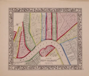
1862 Map ~ PLAN of NEW ORLEANS, LOUISIANA by S. A. Mitchell ~ (12x15)-#13

US $68.00
ApproximatelyS$ 87.71
Condition:
“This 150-year-old map is in good condition, a rare find. It is not *new* or in *new* condition, it ”... Read moreabout condition
Oops! Looks like we're having trouble connecting to our server.
Refresh your browser window to try again.
Shipping:
Free USPS Ground Advantage®.
Located in: Schertz, Texas, United States
Delivery:
Estimated between Sat, 13 Sep and Fri, 19 Sep to 94104
Returns:
30 days return. Seller pays for return shipping.
Coverage:
Read item description or contact seller for details. See all detailsSee all details on coverage
(Not eligible for eBay purchase protection programmes)
Seller assumes all responsibility for this listing.
eBay item number:406060466044
Item specifics
- Seller Notes
- US State
- Louisiana
- Size
- the page is approx. 12x15 inches.
- Color
- Beautiful original vibrant, hand tinted colors.
- Cartographer/Publisher
- S. Augustus Mitchell
- City
- New Orleans
- Date
- Dated in fine print.
- Date Range
- 1800-1899
- Ref
- The title page is only for reference purposes. It is not included
- Type
- City Map
- Format
- Atlas Map
- S&H
- Free S&H USA - Calculated S&H Worldwide
- Year
- 1862
- Original/Reproduction
- Antique Original
- Country/Region
- United States of America
- Age
- over 150 years old
Item description from the seller

Seller feedback (9,765)
- eBay automated Feedback- Feedback left by buyer.Past monthOrder completed successfully – tracked and on time
- eBay automated Feedback- Feedback left by buyer.Past monthOrder completed successfully – tracked and on time
- eBay automated Feedback- Feedback left by buyer.Past monthOrder completed successfully – tracked and on time