Picture 1 of 3


Gallery
Picture 1 of 3


Have one to sell?
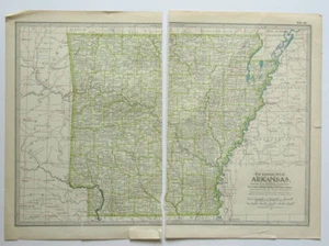
ARKANSAS Map The Century Atlas 1897 Plate No. 44 Antique 16 x 11 Inch AR

US $12.00
ApproximatelyS$ 15.55
Condition:
Oops! Looks like we're having trouble connecting to our server.
Refresh your browser window to try again.
Shipping:
Free USPS Ground Advantage®.
Located in: Berlin, New Hampshire, United States
Delivery:
Estimated between Wed, 15 Oct and Tue, 21 Oct to 94104
Returns:
30 days return. Buyer pays for return shipping. If you use an eBay shipping label, it will be deducted from your refund amount.
Coverage:
Read item description or contact seller for details. See all detailsSee all details on coverage
(Not eligible for eBay purchase protection programmes)
Seller assumes all responsibility for this listing.
eBay item number:373055041104
Item specifics
- Cartographer/Publisher
- The Matthews-Northrup Co.
- Format
- Atlas Map
- US State
- Arkansas
- Publication Year
- 1897
Item description from the seller

Seller feedback (6,873)
- s***y (4147)- Feedback left by buyer.Past monthVerified purchasevery good service
- 3***l (2346)- Feedback left by buyer.Past 6 monthsVerified purchaseFast shipping - nice packing - as described - good value - all from a very nice seller - love the wooden postcard - thank you
- h***e (5120)- Feedback left by buyer.Past 6 monthsVerified purchaseItem arrived safelyBig Diamond Camp Colebrook NH Postcard RPPC Stewartstown Eastern Illustrating Co (#234361182961)