
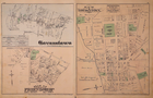
1877 Plat Map 9th District, BALTIMORE Co., MD / TOWNSONTOWN, GOVANSTOWN on Back
US $64.75US $64.75
Jul 16, 00:48Jul 16, 00:48
Picture 1 of 4


Gallery
Picture 1 of 4


Have one to sell?
1877 Plat Map 9th District, BALTIMORE Co., MD / TOWNSONTOWN, GOVANSTOWN on Back
US $64.75
ApproximatelyS$ 83.20
or Best Offer
Was US $68.88 (6% off)
Condition:
“This map is not *new* or in *new* condition. It was removed from an 1877 Baltimore County, Maryland ”... Read moreabout condition
Ended: Jul 16, 2025 00:48:45 SGT
Oops! Looks like we're having trouble connecting to our server.
Refresh your browser window to try again.
Shipping:
Free USPS Ground Advantage®.
Located in: San Antonio, Texas, United States
Delivery:
Estimated between Thu, 28 Aug and Thu, 4 Sep to 94104
Returns:
30 days return. Buyer pays for return shipping. If you use an eBay shipping label, it will be deducted from your refund amount.
Coverage:
Read item description or contact seller for details. See all detailsSee all details on coverage
(Not eligible for eBay purchase protection programmes)
Seller assumes all responsibility for this listing.
eBay item number:356784538428
Item specifics
- Seller Notes
- US State
- Maryland
- Size
- 17" x 23"
- Color
- Original Hand Tinting
- Cartographer/Publisher
- G. M. Hopkins C.E.
- Date Range
- 1800-1899
- Type
- District / Township Map
- Format
- Atlas Map
- Title page
- The book cover and title page are not included in the sale.
- Year
- 1877
- Packaging
- All maps are shipped in a secure water-resistant mailing tube
- Original/Reproduction
- Antique Original
- Ancestry
- Landowners' names - Property boundaries - Family History
- Shipping
- Free S&H USA - Calculated S&H Worldwide
- Country/Region
- United States of America
Item description from the seller
Seller Feedback
No feedback yet