
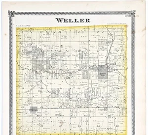
1875 Plat Map WELLER - Township ILLINOIS - Henry County (16x13) ORIGINAL
US $40.00US $40.00
Sep 25, 05:46Sep 25, 05:46
Picture 1 of 4


Gallery
Picture 1 of 4


Have one to sell?
1875 Plat Map WELLER - Township ILLINOIS - Henry County (16x13) ORIGINAL

Condition:
“FAIR CONDITION, EDGE TEARS AT BOTTOM, DISCOLORATION DUE TO AGE”
Ended: Sep 25, 2025 05:46:39 SGT
Oops! Looks like we're having trouble connecting to our server.
Refresh your browser window to try again.
Shipping:
Free USPS Ground Advantage®.
Located in: Carefree, Arizona, United States
Delivery:
Estimated between Mon, 29 Sep and Sat, 4 Oct to 94104
Returns:
30 days return. Seller pays for return shipping.
Coverage:
Read item description or contact seller for details. See all detailsSee all details on coverage
(Not eligible for eBay purchase protection programmes)
Seller assumes all responsibility for this listing.
eBay item number:326780827568
Item specifics
- Seller Notes
- “FAIR CONDITION, EDGE TEARS AT BOTTOM, DISCOLORATION DUE TO AGE”
- US State
- Illinois
- Printing Technique
- Lithography
- Cartographer/Publisher
- WARNER AND BEERS
- City
- WELLER
- Source
- Atlas of Henry county Illinois, 1875
- Date Range
- 1800-1899
- Type
- Plat map
- Format
- Atlas Map
- Depicts
- Townships, property owners names and plats
- Year
- 1875
- Original/Reproduction
- Antique Original
- Country/Region
- United States of America
- AGE
- Original 150 year old map
Item description from the seller

Seller feedback (6,524)
- eBay automated feedback- Feedback left by buyer.Past monthOrder completed successfully—tracked and on time
- eBay automated feedback- Feedback left by buyer.Past monthOrder completed successfully—tracked and on time
- eBay automated feedback- Feedback left by buyer.Past monthOrder completed successfully—tracked and on time