Picture 1 of 7


Gallery
Picture 1 of 7


Have one to sell?
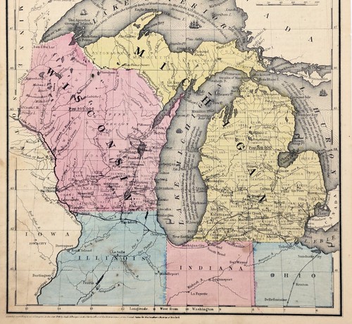
2 MAPS MICHIGAN - WISCONSIN Map Original UPPER PENINSULA 1848 & 1853

US $31.96
ApproximatelyS$ 41.00
or Best Offer
Was US $34.00 (6% off)
Condition:
“FAIR CONDITION, DISCOLORATION, TEXT ON REVERSE”
Oops! Looks like we're having trouble connecting to our server.
Refresh your browser window to try again.
Shipping:
Free USPS Ground Advantage®.
Located in: Carefree, Arizona, United States
Delivery:
Estimated between Sat, 27 Sep and Fri, 3 Oct to 94104
Returns:
30 days return. Seller pays for return shipping.
Coverage:
Read item description or contact seller for details. See all detailsSee all details on coverage
(Not eligible for eBay purchase protection programmes)
Seller assumes all responsibility for this listing.
eBay item number:326766280854
Item specifics
- Seller Notes
- “FAIR CONDITION, DISCOLORATION, TEXT ON REVERSE”
- Date Range
- 1800-1899
- Type
- County Map
- US State
- Michigan, Wisconsin
- Format
- Atlas Map
- Printing Technique
- Lithography
- Year
- 1848 AND 1853
- Original/Reproduction
- Antique Original
- Cartographer/Publisher
- DANIEL BURGESS
- City
- GREEN BAY
- Country/Region
- United States of America
- Country/Region of Manufacture
- United States
Item description from the seller

Seller feedback (6,519)
- i***k (633)- Feedback left by buyer.Past monthVerified purchaseArrived fast and in perfect condition. I am glad to have this piece of history. Thanks
- i***k (633)- Feedback left by buyer.Past monthVerified purchaseArrived fast and in perfect condition. Thanks,
- i***k (633)- Feedback left by buyer.Past monthVerified purchaseArrived fast and in perfect condition. Thanks,