Picture 1 of 8


Gallery
Picture 1 of 8


Have one to sell?
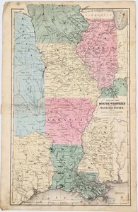
1847 WESTERN & SOUTH WEST STATES Map ORIGINAL (18X10.5) TEXAS INDIAN TERRITORY

US $138.00
ApproximatelyS$ 176.68
or Best Offer
Condition:
“GOOD CONDITION, DISCOLORATION AND STAINING, CENTER CREASE AS ISSUED, BENT/BUMPED CORNERS AT TOP LEFT ”... Read moreabout condition
Oops! Looks like we're having trouble connecting to our server.
Refresh your browser window to try again.
Shipping:
Free USPS Ground Advantage®.
Located in: Carefree, Arizona, United States
Delivery:
Estimated between Wed, 16 Jul and Tue, 22 Jul to 94104
Returns:
30 days return. Seller pays for return shipping.
Coverage:
Read item description or contact seller for details. See all detailsSee all details on coverage
(Not eligible for eBay purchase protection programmes)
Seller assumes all responsibility for this listing.
eBay item number:326680838327
Item specifics
- Seller Notes
- Date Range
- 1800-1899
- Type
- Political Map
- US State
- Arkansas, Illinois, Iowa, Kansas, Kentucky, Louisiana, Mississippi, Missouri, Nebraska, Oklahoma, Texas
- Format
- Atlas Map
- Printing Technique
- Copper Plate
- Year
- 1847
- Original/Reproduction
- Antique Original
- Cartographer/Publisher
- D. F. ROBINSON
- City
- Houston
- Country/Region
- United States of America
Item description from the seller

Seller feedback (6,305)
- a***s (501)- Feedback left by buyer.Past monthVerified purchaseI love maps and this one is a beauty! Great price and fast shipping.
- 7***7 (861)- Feedback left by buyer.Past monthVerified purchaseAAA+++
- 7***7 (861)- Feedback left by buyer.Past monthVerified purchaseGreat map.