Picture 1 of 6


Gallery
Picture 1 of 6


Have one to sell?
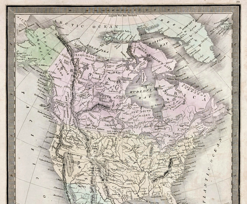
1848 NORTH AMERICA Map GREENLEAF Original TEXAS - OREGON - FLORIDA - MICHIGAN

US $140.00
ApproximatelyS$ 179.96
or Best Offer
Condition:
“GOOD CONDITION, DISCOLORATION”
Oops! Looks like we're having trouble connecting to our server.
Refresh your browser window to try again.
Shipping:
Free USPS Ground Advantage®.
Located in: Carefree, Arizona, United States
Delivery:
Estimated between Thu, 14 Aug and Wed, 20 Aug to 94104
Returns:
30 days return. Seller pays for return shipping.
Coverage:
Read item description or contact seller for details. See all detailsSee all details on coverage
(Not eligible for eBay purchase protection programmes)
Seller assumes all responsibility for this listing.
eBay item number:326615037225
Item specifics
- Seller Notes
- “GOOD CONDITION, DISCOLORATION”
- Date Range
- 1800-1899
- Type
- Political Map
- US State
- AR, IA, KS, LA, MO, NE, AZ, CA, CO, NM, NV, UT, Iowa, Minnesota, Texas, Wisconsin
- Format
- Atlas Map
- Printing Technique
- Copper Plate
- Year
- 1848
- Original/Reproduction
- Antique Original
- Cartographer/Publisher
- Jeremiah Greenleaf
- City
- AUSTIN
- Country/Region
- United States of America
Item description from the seller

Seller feedback (6,376)
- e***r (4469)- Feedback left by buyer.Past monthVerified purchaseArrived promptly perfectly packaged as described.
- d***d (413)- Feedback left by buyer.Past monthVerified purchaseItem arrived in a timely manner and in good condition.
- m***y (112)- Feedback left by buyer.Past monthVerified purchaseWhat a neat and unique map. Incredibly pleased… Shipped quickly, packaged safely and exactly as described. 
Seller feedback (6,376)
- e***r (4469)- Feedback left by buyer.Past monthVerified purchaseArrived promptly perfectly packaged as described.
- d***d (413)- Feedback left by buyer.Past monthVerified purchaseItem arrived in a timely manner and in good condition.
- m***y (112)- Feedback left by buyer.Past monthVerified purchaseWhat a neat and unique map. Incredibly pleased… Shipped quickly, packaged safely and exactly as described.