Picture 1 of 8


Gallery
Picture 1 of 8


Have one to sell?
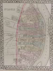
1873 Mitchell's Atlas Map City Plan St. Louis, Authentic Hand-Colored 12 x 16"

US $70.00
ApproximatelyS$ 90.15
or Best Offer
Was US $100.00 (30% off)
Condition:
“Very good condition. Only minimal wear and browning that is confined to the edges. THIS MAP IS VERY ”... Read moreabout condition
Sale ends in: 2h 37m
Oops! Looks like we're having trouble connecting to our server.
Refresh your browser window to try again.
Shipping:
US $11.95 (approx S$ 15.39) Economy Shipping.
Located in: Swampscott, Massachusetts, United States
Delivery:
Estimated between Tue, 9 Sep and Mon, 15 Sep to 94104
Returns:
30 days return. Buyer pays for return shipping. If you use an eBay shipping label, it will be deducted from your refund amount.
Coverage:
Read item description or contact seller for details. See all detailsSee all details on coverage
(Not eligible for eBay purchase protection programmes)
Seller assumes all responsibility for this listing.
eBay item number:326554745652
Item specifics
- Seller Notes
- City
- St. Louis
- Type
- City Map
- Format
- Atlas Map
- Year
- 1873
- Date Range
- 1800-1899
- Printing Technique
- Lithography
- US State
- Missouri
- Cartographer/Publisher
- Samuel Augustus Mitchell
- Original/Reproduction
- Antique Original
- Country/Region
- United States of America
Item description from the seller

Seller feedback (1,951)
- e***e (410)- Feedback left by buyer.Past monthVerified purchase+ + +
- eBay automated Feedback- Feedback left by buyer.Past monthOrder completed successfully – tracked and on time
- n***o (677)- Feedback left by buyer.Past monthVerified purchaseGreat item, fast shipping
Seller feedback (1,951)
- e***e (410)- Feedback left by buyer.Past monthVerified purchase+ + +
- eBay automated Feedback- Feedback left by buyer.Past monthOrder completed successfully – tracked and on time
- n***o (677)- Feedback left by buyer.Past monthVerified purchaseGreat item, fast shipping