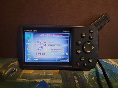
Garmin GPSMAP 296 Aviation
US $149.95US $149.95
Jul 20, 23:20Jul 20, 23:20
Picture 1 of 4


Gallery
Picture 1 of 4


Have one to sell?
Garmin GPSMAP 296 Aviation
US $149.95
ApproximatelyS$ 192.78
Condition:
For parts or not working
An item that does not function as intended and is not fully operational. This includes items that are defective in ways that render them difficult to use, items that require service or repair, or items missing essential components. See the seller's listing for full details.
Oops! Looks like we're having trouble connecting to our server.
Refresh your browser window to try again.
Shipping:
Free USPS Ground Advantage®.
Located in: Lake City, Florida, United States
Delivery:
Estimated between Sat, 30 Aug and Mon, 8 Sep to 94104
Returns:
No returns accepted.
Coverage:
Read item description or contact seller for details. See all detailsSee all details on coverage
(Not eligible for eBay purchase protection programmes)
Seller assumes all responsibility for this listing.
eBay item number:306287221262
Item specifics
- Condition
- Model
- Garmin GPSMAP
- UPC
- 0753759046026
About this product
Product Information
Find your ideal companion for your land or air escapades in the Garmin GPSMAP 296 Aviation. This GPS receiver features fast processing speeds and supports USB data transfers. It displays your route over realistic topography. With this Garmin on board, a pilot can record his departures and arrivals automatically while tracking his flight hours at the same time with the built-in logbook. The integrated FlightBook software lets you manage and save all of your aviation data and have your information ready for printing when you need it.Enhancements to the software for the GPSMAP have increased the user’s ability to move waypoints while editing a route. Saving your current location as a waypoint is made easy with this GPSMAP. You simply press and hold the ENTER/MARK button. When used with FlightBook, Garmin's free logbook software, this allows a pilot to create, manage, analyze, save, and print flight data.A detailed Jeppesen database, along with terrain and U.S. obstacle databases, is built into this GPS unit. Update the device with all of your preferred GPS maps. It’s easy with the help of the convenient plug-and-play Garmin data cards. If a day on the road is your thing, it is easy to switch the unit to automotive mode. The auto mode has a built-in routable basemap. Add the optional MapSource detailed street maps to your GPSMAP for more in-depth information about where you’re driving. You can be given voice-prompted, turn-by-turn directions to addresses and nearby points of interest. This GPS device is also sufficiently water-resistant for its marine mode, where it can be customized with optional marine cartography.The unit’s 256-color, high-resolution sunlight-readable TFT display screen features 320 by 480 pixels. It also offers adjustable backlighting that makes it easy to see in any condition. GPS position, GPS altitude, and topographical mapping are combined to provide a vivid depiction of potential hazards. A configurable look-ahead warning function gives you additional time to make critical decisions. When flying, you can select a proximity alert at 60, 90, or 120 seconds. The minimum limits can be set to receive terrain cautions. Potential hazards are displayed in yellow to indicate ground proximity of 500 to 1,000 feet. To indicate a proximity of 100 feet or less, the hazards are displayed in red. This means that as your aircraft approaches an obstacle, you will be alerted and can increase your altitude. The terrain shown on the display will gradually change color from red to yellow (500 to 1,000 feet clearance) as you climb. It shows black when you have cleared an obstacle.To make this GPS even more convenient, it can be recharged from a standard cigarette lighter socket. That means you can keep the device charged and ready for use when you need it.
Product Identifiers
Brand
Garmin
MPN
010-00356-00
UPC
0753759046026, 0753759074968
Model
GPSMAP 296
eBay Product ID (ePID)
66149794
Product Key Features
Features
Waterproof
Screen Size
3.5"
Type
Aviation
Dimensions
Weight
0.85lb.
Depth
1.9in
Height
3.2in
Width
5.7in
Additional Product Features
Battery Type and Quantity
Rechargeable Li-ion Battery
Battery Life
15h
Number of Channels
12 Channels
Trip Calculator
Total Average, Maximum Speed, Odometer, Moving Average, Route Recalculation
User Interface
Keypad
Display Size
3.2x2.1in
Unit Size
Not Applicable
Usage
Aviation
System Type
Portable
Item description from the seller
Seller feedback (1,108)
- e***e (342)- Feedback left by buyer.Past monthVerified purchasegood
- u***1 (67)- Feedback left by buyer.Past monthVerified purchaseThe product looks exactly like it is in the picture. The seller is nice and easy to communicate with.
- t***o (655)- Feedback left by buyer.Past monthVerified purchaseFirst class seller. As described./ Thank you for packaging so well.