Picture 1 of 1
Gallery
Picture 1 of 1

Have one to sell?
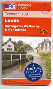
Ordnance Survey Explorer map no. 289 Leeds, Harrogate, Wetherby.. 2000 ed.
GBP 3.00
ApproximatelyS$ 5.22
Condition:
“good condition”
Good
A book that has been read but is in good condition. Very minimal damage to the cover including scuff marks, but no holes or tears. The dust jacket for hard covers may not be included. Binding has minimal wear. The majority of pages are undamaged with minimal creasing or tearing, minimal pencil underlining of text, no highlighting of text, no writing in margins. No missing pages.
Oops! Looks like we're having trouble connecting to our server.
Refresh your browser window to try again.
Shipping:
Located in: Grangemouth, United Kingdom
Delivery:
Varies
Returns:
No returns accepted.
Coverage:
Read item description or contact seller for details. See all detailsSee all details on coverage
(Not eligible for eBay purchase protection programmes)
Seller assumes all responsibility for this listing.
eBay item number:267380171620
Item specifics
- Condition
- Good
- Seller Notes
- “good condition”
- Personalised
- No
- Publication Year
- 2000
- Series
- Explorer series
- Type
- Hiking Map
- Publication Name
- N/A
- Region
- south Yorkshire
- Map Scale
- 1:25,000
- Publisher
- Ordnance Survey
- ISBN
- N/A
Item description from the seller
Seller feedback (2,207)
- f***e (2442)- Feedback left by buyer.Past monthVerified purchaseVery interesting in good condition and fast delivery
- s***r (1984)- Feedback left by buyer.Past monthVerified purchaseGreat thanks
- f***e (2967)- Feedback left by buyer.Past monthVerified purchaseexcellent transaction