Picture 1 of 4


Gallery
Picture 1 of 4


Have one to sell?
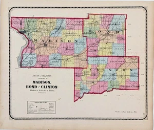
1871 MADISON BOND CLINTON - ILLINOIS Counties Map ORIGINAL (16X13)

US $52.00
ApproximatelyS$ 66.67
or Best Offer
Condition:
“GOOD CONDITION- MINOR DISCOLORATION”
Oops! Looks like we're having trouble connecting to our server.
Refresh your browser window to try again.
Shipping:
Free USPS Ground Advantage®.
Located in: Carefree, Arizona, United States
Delivery:
Estimated between Fri, 26 Sep and Thu, 2 Oct to 94104
Returns:
30 days return. Seller pays for return shipping.
Coverage:
Read item description or contact seller for details. See all detailsSee all details on coverage
(Not eligible for eBay purchase protection programmes)
Seller assumes all responsibility for this listing.
eBay item number:226988869853
Item specifics
- Seller Notes
- “GOOD CONDITION- MINOR DISCOLORATION”
- Date Range
- 1800-1899
- Type
- County Map
- US State
- Illinois
- Format
- Atlas Map
- Printing Technique
- Lithography
- Year
- 1871
- COLOR
- ORIGINAL 1871 HAND-COLORING, VIBRANT
- Original/Reproduction
- Antique Original
- Cartographer/Publisher
- Warner, Higgins and Beers
- Atlas Source
- Beer's Atlas of the State of Illinois
- City
- EDWARDSVILLE
- Country/Region
- United States of America
Item description from the seller

Seller feedback (6,518)
- eBay automated feedback- Feedback left by buyer.Past monthOrder completed successfully—tracked and on time
- eBay automated feedback- Feedback left by buyer.Past monthOrder completed successfully—tracked and on time
- eBay automated feedback- Feedback left by buyer.Past monthOrder completed successfully—tracked and on time