Picture 1 of 4


Gallery
Picture 1 of 4


Have one to sell?
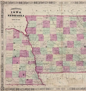
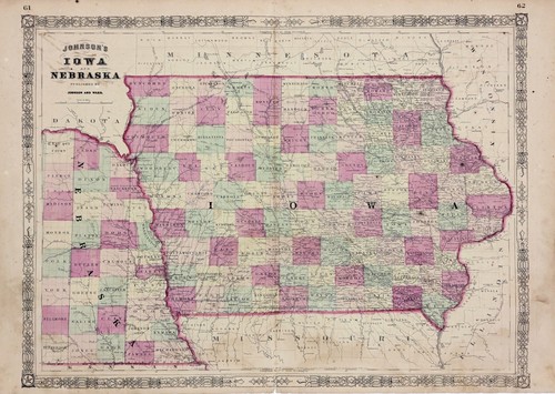
1864 IOWA - NEBRASKA TERRITORY Map ORIGINAL (23x17) RAILROADS Civil War Era

US $42.00
ApproximatelyS$ 53.85
or Best Offer
Condition:
Oops! Looks like we're having trouble connecting to our server.
Refresh your browser window to try again.
Shipping:
Free USPS Ground Advantage®.
Located in: Carefree, Arizona, United States
Delivery:
Estimated between Fri, 26 Sep and Thu, 2 Oct to 94104
Returns:
30 days return. Seller pays for return shipping.
Coverage:
Read item description or contact seller for details. See all detailsSee all details on coverage
(Not eligible for eBay purchase protection programmes)
Seller assumes all responsibility for this listing.
eBay item number:226983002785
Item specifics
- Date Range
- 1800-1899
- Type
- County Map
- US State
- Iowa, Minnesota
- Format
- Atlas Map
- Printing Technique
- Lithography
- Title page
- Title Page shown for reference only, not included
- Year
- 1864
- Original/Reproduction
- Antique Original
- Cartographer/Publisher
- JOHNSON AND WARD
- City
- DUBUQUE
- Country/Region
- United States of America
- ATLAS SOURCE
- Johnson's Atlas of 1864,
Item description from the seller

Seller feedback (6,517)
- eBay 自動留下信用評價- Feedback left by buyer.Past month訂單成功完成 — 物品享追蹤服務且準時送達
- eBay 自動留下信用評價- Feedback left by buyer.Past month訂單成功完成 — 物品享追蹤服務且準時送達
- eBay 自動留下信用評價- Feedback left by buyer.Past month訂單成功完成 — 物品享追蹤服務且準時送達
Seller feedback (6,517)
- eBay 自動留下信用評價- Feedback left by buyer.Past month訂單成功完成 — 物品享追蹤服務且準時送達
- eBay 自動留下信用評價- Feedback left by buyer.Past month訂單成功完成 — 物品享追蹤服務且準時送達
- eBay 自動留下信用評價- Feedback left by buyer.Past month訂單成功完成 — 物品享追蹤服務且準時送達