Picture 1 of 4


Gallery
Picture 1 of 4


Have one to sell?
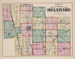
1875 OHIO - DELAWARE County Map ORIGINAL (16X12) Liberty - Brown - Orange

Condition:
“GOOD CONDITION, DISCOLORATION DUE TO AGE”
Oops! Looks like we're having trouble connecting to our server.
Refresh your browser window to try again.
Shipping:
Free USPS Ground Advantage®.
Located in: Carefree, Arizona, United States
Delivery:
Estimated between Sat, 19 Jul and Thu, 24 Jul
Returns:
30 days return. Seller pays for return shipping.
Coverage:
Read item description or contact seller for details. See all detailsSee all details on coverage
(Not eligible for eBay purchase protection programmes)
Seller assumes all responsibility for this listing.
eBay item number:226861064078
Item specifics
- Seller Notes
- “GOOD CONDITION, DISCOLORATION DUE TO AGE”
- US State
- Ohio
- Printing Technique
- Lithography
- Cartographer/Publisher
- L.H. Everts and Co.
- City
- Orange
- Source
- Atlas of Delaware county Ohio, 1875
- Date Range
- 1800-1899
- Type
- County Map
- Format
- Atlas Map
- Depicts
- Townships, Railroads, Schools, Churches
- Year
- 1875
- Original/Reproduction
- Antique Original
- Country/Region
- United States of America
- AGE
- Original 150 year old map
Item description from the seller

Seller feedback (6,305)
- a***s (501)- Feedback left by buyer.Past monthVerified purchaseI love maps and this one is a beauty! Great price and fast shipping.
- 7***7 (861)- Feedback left by buyer.Past monthVerified purchaseAAA+++
- 7***7 (861)- Feedback left by buyer.Past monthVerified purchaseGreat map.