Picture 1 of 4


Gallery
Picture 1 of 4


Have one to sell?
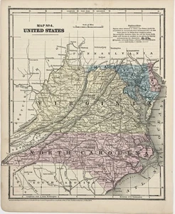
1860 VIRGINIA - NORTH CAROLINA - MARYLAND Map ORIGINAL Burgess Smith (10X8.5)

Condition:
“GOOD CONDITION, DISCOLORATION, TEXT ON REVERSE”
Oops! Looks like we're having trouble connecting to our server.
Refresh your browser window to try again.
Shipping:
Free USPS Ground Advantage®.
Located in: Carefree, Arizona, United States
Delivery:
Estimated between Thu, 17 Jul and Wed, 23 Jul to 94104
Returns:
30 days return. Seller pays for return shipping.
Coverage:
Read item description or contact seller for details. See all detailsSee all details on coverage
(Not eligible for eBay purchase protection programmes)
Seller assumes all responsibility for this listing.
eBay item number:226857315624
Item specifics
- Seller Notes
- “GOOD CONDITION, DISCOLORATION, TEXT ON REVERSE”
- Date Range
- 1800-1899
- Type
- Map
- Format
- Atlas Map
- Printing Technique
- Lithography
- US State
- Delaware, Maryland, North Carolina, Virginia, West Virginia
- Year
- 1860
- Original/Reproduction
- Antique Original
- Cartographer/Publisher
- Daniel Burgess
- City
- Washington
- Country/Region
- United States of America
Item description from the seller

Seller feedback (6,305)
- a***s (501)- Feedback left by buyer.Past monthVerified purchaseI love maps and this one is a beauty! Great price and fast shipping.
- 7***7 (861)- Feedback left by buyer.Past monthVerified purchaseAAA+++
- 7***7 (861)- Feedback left by buyer.Past monthVerified purchaseGreat map.