Picture 1 of 17


Gallery
Picture 1 of 17


Have one to sell?
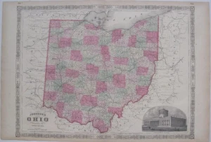
Original Hand Color 1865 Johnson & Ward OHIO County Map Canals Railroads Capitol

US $49.99
ApproximatelyS$ 64.26
Condition:
“SEE BELOW FOR FULL DESCRIPTION. Excellent condition, sound and clean, with a vertical center fold, ”... Read moreabout condition
Oops! Looks like we're having trouble connecting to our server.
Refresh your browser window to try again.
Shipping:
US $6.00 (approx S$ 7.71) USPS First Class®.
Located in: Lake Worth, Florida, United States
Delivery:
Estimated between Thu, 14 Aug and Wed, 20 Aug to 91768
Returns:
30 days return. Seller pays for return shipping.
Coverage:
Read item description or contact seller for details. See all detailsSee all details on coverage
(Not eligible for eBay purchase protection programmes)
Seller assumes all responsibility for this listing.
eBay item number:226835820493
Item specifics
- Seller Notes
- US State
- Ohio
- Format
- Atlas Map
- Type
- Political Map
- Date Range
- 1800-1899
- Original/Reproduction
- Antique Original
- Country/Region
- United States of America
- Printing Technique
- Lithography
- Cartographer/Publisher
- Johnson & Ward
- Year
- 1865
- Product_Type
- Antique Map
Item description from the seller

Seller feedback (27,087)
- u***t (414)- Feedback left by buyer.Past monthVerified purchaseGreat little item. Well packaged. Fast delivery.
- l***l (16)- Feedback left by buyer.Past monthVerified purchaseShipped very fast, packaging was great, just as described and the value was very good.
- j***t (1321)- Feedback left by buyer.Past monthVerified purchasePerfect! Thanks!!