Picture 1 of 5


Gallery
Picture 1 of 5


Have one to sell?
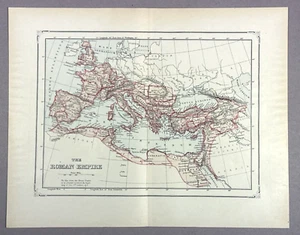
Antique Illustration Map of The Roman Empire in 2nd Century Encyclopedia 1901
US $14.88
ApproximatelyS$ 19.19
or Best Offer
Condition:
“Antique condition with wear. Page size is approximately 13.5" x 10.75" See photos/description”
Oops! Looks like we're having trouble connecting to our server.
Refresh your browser window to try again.
Shipping:
US $5.75 (approx S$ 7.42) Standard Shipping.
Located in: Wallkill, New York, United States
Delivery:
Estimated between Wed, 10 Sep and Tue, 16 Sep to 94104
Returns:
30 days return. Buyer pays for return shipping. If you use an eBay shipping label, it will be deducted from your refund amount.
Coverage:
Read item description or contact seller for details. See all detailsSee all details on coverage
(Not eligible for eBay purchase protection programmes)
Seller assumes all responsibility for this listing.
eBay item number:205122715156
Item specifics
- Seller Notes
- “Antique condition with wear. Page size is approximately 13.5" x 10.75" See photos/description”
- Date Range
- 1900-1909
- Format
- Atlas Map
- Original/Reproduction
- Antique Original
- Printing Technique
- Lithography
- Year
- 1901
- Type
- World Atlas
- City
- Rome
- Country/Region
- Germany, Italy
Item description from the seller
Popular categories from this store
Seller feedback (1,837)
- eBay automated feedback- Feedback left by buyer.Past monthOrder completed successfully—tracked and on time
- eBay automated feedback- Feedback left by buyer.Past monthOrder completed successfully—tracked and on time
- g***. (166)- Feedback left by buyer.Past monthVerified purchaseSuper easy purchase and fair pricing for a used, vintage item. I look forward to working with seller again if given the opportunity. Thank you again