Picture 1 of 1
Gallery
Picture 1 of 1

Have one to sell?
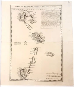
Antique map, Chatelain, Carte des Antilles Francois et des isles voisines, 1719

GBP 160.00
ApproximatelyS$ 277.29
or Best Offer
Condition:
“very good condition”
Oops! Looks like we're having trouble connecting to our server.
Refresh your browser window to try again.
Returns:
30 days return. Buyer pays for return shipping. If you use an eBay shipping label, it will be deducted from your refund amount.
Coverage:
Read item description or contact seller for details. See all detailsSee all details on coverage
(Not eligible for eBay purchase protection programmes)
Seller assumes all responsibility for this listing.
eBay item number:186274382561
Item specifics
- Seller Notes
- “very good condition”
- Date Range
- 1700-1799
- Antique
- Yes
- Type
- Topographical Map
- Printing Technique
- Copper Plate
- Format
- Atlas Map
- Year
- 1719
- Era
- 1700s
- Original/Reproduction
- Antique Original
- Cartographer/Publisher
- Chatelain
- Country/Region
- Barbados, Martinique, Saint Lucia, Saint Vincent & the Grenadines
Item description from the seller

Seller feedback (708)
- 0***o (227)- Feedback left by buyer.Past monthVerified purchasePerfect
- 0***o (227)- Feedback left by buyer.Past monthVerified purchasePerfect
- 0***o (227)- Feedback left by buyer.Past monthVerified purchasePerfect
Seller feedback (708)
- 0***o (227)- Feedback left by buyer.Past monthVerified purchasePerfect
- 0***o (227)- Feedback left by buyer.Past monthVerified purchasePerfect
- 0***o (227)- Feedback left by buyer.Past monthVerified purchasePerfect