Picture 1 of 1
Gallery
Picture 1 of 1

Have one to sell?
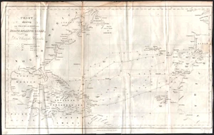
1849 CHRISTOPHER COLUMBUS OCEAN ROUTE antique folded map NORTH ATLANTIC OCEAN

US $14.99
ApproximatelyS$ 19.39
or Best Offer
Condition:
“Good condition: creases and fold seams, edge wear.”
Oops! Looks like we're having trouble connecting to our server.
Refresh your browser window to try again.
Shipping:
US $8.00 (approx S$ 10.35) USPS Ground Advantage®.
Located in: Albany, Oregon, United States
Save on combined shipping
Delivery:
Estimated between Fri, 10 Oct and Tue, 14 Oct to 94104
Returns:
30 days return. Seller pays for return shipping.
Coverage:
Read item description or contact seller for details. See all detailsSee all details on coverage
(Not eligible for eBay purchase protection programmes)
Seller assumes all responsibility for this listing.
eBay item number:167154106870
Item specifics
- Seller Notes
- “Good condition: creases and fold seams, edge wear.”
- Date Range
- 1800-1899
- Type
- Nautical Map
- Format
- Sheet Map
- Printing Technique
- Copper Plate
- Year
- 1849
- Original/Reproduction
- Antique Original
- Cartographer/Publisher
- George P. Putnam
- City
- Havana
- Country/Region
- Cuba
- Subject
- Christopher Columbus
Item description from the seller

Seller feedback (25,733)
- Automatische feedback van eBay- Feedback left by buyer.Past monthBestelling op tijd geleverd zonder problemen
- Automatische feedback van eBay- Feedback left by buyer.Past monthBestelling op tijd geleverd zonder problemen
- Automatische feedback van eBay- Feedback left by buyer.Past monthBestelling op tijd geleverd zonder problemen