Picture 1 of 8


Gallery
Picture 1 of 8


Have one to sell?
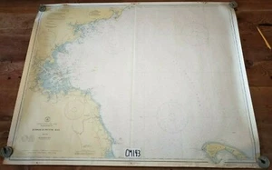
Map Nautical Chart Massachusetts Bay #1207 1938 U.S.C & GS 35 Vintage

US $26.97
ApproximatelyS$ 34.65
or Best Offer
Condition:
“There are tack holes from mounting and staining on top and bottom border around tack holes. Bottom ”... Read moreabout condition
Oops! Looks like we're having trouble connecting to our server.
Refresh your browser window to try again.
Shipping:
US $25.05 (approx S$ 32.18) USPS Ground Advantage®.
Located in: Mansfield, Massachusetts, United States
Delivery:
Estimated between Wed, 24 Sep and Tue, 30 Sep to 94104
Returns:
30 days return. Seller pays for return shipping.
Coverage:
Read item description or contact seller for details. See all detailsSee all details on coverage
(Not eligible for eBay purchase protection programmes)
Seller assumes all responsibility for this listing.
eBay item number:156811285212
Item specifics
- Seller Notes
- Country/Region of Origin
- United States
- Military Branch
- Civilian
- Original/Reproduction
- Vintage Original
- Time Period, War
- WWII
- Maker
- U.S. and Geodetic Survey Dept. Of Commerce
Item description from the seller

Seller feedback (1,907)
- eBay automated feedback- Feedback left by buyer.Past monthOrder completed successfully—tracked and on time
- eBay automated feedback- Feedback left by buyer.Past monthOrder completed successfully—tracked and on time
- eBay automated feedback- Feedback left by buyer.Past monthOrder completed successfully—tracked and on time
This is a private listing and your identity will not be disclosed to anyone except the seller.
Seller feedback (1,907)
- eBay automated feedback- Feedback left by buyer.Past monthOrder completed successfully—tracked and on time
- eBay automated feedback- Feedback left by buyer.Past monthOrder completed successfully—tracked and on time
- eBay automated feedback- Feedback left by buyer.Past monthOrder completed successfully—tracked and on time