Picture 1 of 5


Gallery
Picture 1 of 5


Have one to sell?
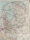
Antique Map Netherlands & Belgium Dated 1887 Europe Colour Map Of The World Art

GBP 13.99
ApproximatelyS$ 24.33
Condition:
Oops! Looks like we're having trouble connecting to our server.
Refresh your browser window to try again.
Shipping:
GBP 4.95 (approx S$ 8.61) Standard Int'l Postage.
Located in: Great Torrington, Devon, United Kingdom
Delivery:
Estimated between Wed, 20 Aug and Fri, 29 Aug to 94104
Returns:
No returns accepted.
Coverage:
Read item description or contact seller for details. See all detailsSee all details on coverage
(Not eligible for eBay purchase protection programmes)
Seller assumes all responsibility for this listing.
eBay item number:135823550673
Item specifics
- Antique
- Yes
- Printing Technique
- Lithography
- Cartographer/Publisher
- J BATHOLOMEW
- City
- Brussels
- County
- N/A
- Date Range
- 1800-1899
- Type
- World Atlas
- Format
- Folding Map
- Year
- 1887
- Era
- 1800s
- State
- various
- Original/Reproduction
- Antique Original
- Country/Region
- Europe
Item description from the seller

Seller feedback (4,167)
- Automatische Bewertung von eBay- Feedback left by buyer.Past monthBestellung erfolgreich durchgeführt - mit Sendungsverfolgung und fristgerecht
- Automatische Bewertung von eBay- Feedback left by buyer.Past monthBestellung erfolgreich durchgeführt - mit Sendungsverfolgung und fristgerecht
- Automatische Bewertung von eBay- Feedback left by buyer.Past monthBestellung erfolgreich durchgeführt - mit Sendungsverfolgung und fristgerecht