Picture 1 of 6


Gallery
Picture 1 of 6


Have one to sell?
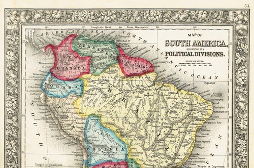
1860 Antique Map of South America Political Divisions 12" x 15" Mitchell's Atlas

US $39.50
ApproximatelyS$ 50.64
Condition:
“Map is Excellent. Spectacular bright and tight. 12" X 15". Hand-colored. Few light spots in the ”... Read moreabout condition
Oops! Looks like we're having trouble connecting to our server.
Refresh your browser window to try again.
Shipping:
US $5.65 (approx S$ 7.24) Economy Shipping.
Located in: Wilmington, North Carolina, United States
Delivery:
Estimated between Sat, 27 Sep and Fri, 3 Oct to 94104
Returns:
14 days return. Buyer pays for return shipping. If you use an eBay shipping label, it will be deducted from your refund amount.
Coverage:
Read item description or contact seller for details. See all detailsSee all details on coverage
(Not eligible for eBay purchase protection programmes)
Seller assumes all responsibility for this listing.
eBay item number:116437126784
Item specifics
- Seller Notes
- Date Range
- 1800-1899
- Type
- Political Map
- Printing Technique
- Lithography
- Format
- Atlas
- Year
- 1860
- Original/Reproduction
- Antique Original
- Country/Region
- South America
Item description from the seller

Seller feedback (3,998)
- Évaluations automatiques eBay- Feedback left by buyer.Past monthCommande terminée - avec suivi et dans les délais
- Évaluations automatiques eBay- Feedback left by buyer.Past monthCommande terminée - avec suivi et dans les délais
- Évaluations automatiques eBay- Feedback left by buyer.Past monthCommande terminée - avec suivi et dans les délais
This is a private listing and your identity will not be disclosed to anyone except the seller.
Seller feedback (3,998)
- Évaluations automatiques eBay- Feedback left by buyer.Past monthCommande terminée - avec suivi et dans les délais
- Évaluations automatiques eBay- Feedback left by buyer.Past monthCommande terminée - avec suivi et dans les délais
- Évaluations automatiques eBay- Feedback left by buyer.Past monthCommande terminée - avec suivi et dans les délais