Vintage Original Antique North America County Maps
652 Results
1941 - PROVINCE OF QUEBEC (CANADA) - HIGHWAY AND TOURIST - MAP - ORIGINAL
S$ 32.36S$ 53.92 shippingVtg 1984-1985 Aerial Photo Map Book California San Diego County Rare Atlas
S$ 294.88S$ 95.86 shippingVintage 1949 LARGE MARYLAND MAP - HOWARD COUNTY Topography & Election Districts
S$ 190.21S$ 59.44 shippingVintage 1948 (36" x 23") MARYLAND MAP - HARFORD COUNTY Topo & Election Districts
S$ 190.21S$ 59.44 shippingParis Kentucky County Seat Of Bourbon Fold-Out Map 5th Edition 1954
S$ 22.12S$ 50.84 shippingVintage Maps -Jasper & Dubois County Indiana -Lot of 4
S$ 5.071 bidS$ 86.73 shippingEnding Thursday at 4:07 SGT15h 14mBucks County Pennsylvania PA Historical Sketch Map 1952 by Anne Chestnut 19x22"
S$ 35.39S$ 57.83 shipping1912 Plat Map ~ ADAMS Twp., DOUGLAS Co., MINNESOTA ~ Free S&H
S$ 45.990 bidsS$ 28.77 shippingEnding Thursday at 5:58 SGT17h 5m1912 Plat Map ~ ISLAND GROVE Twp., DOUGLAS Co., MINNESOTA - LIBERTY ~ Free S&H
S$ 45.990 bidsS$ 28.77 shippingEnding Thursday at 8:02 SGT19h 9m1912 Plat Map ~ OSAKIS - MILTONA BEACH - NELSON Twp., DOUGLAS Co., MINNESOTA
S$ 45.990 bidsS$ 28.77 shippingEnding Thursday at 8:24 SGT19h 31m1912 Plat Map ~ RIVERSIDE Twp., DOUGLAS Co., MINNESOTA - BEATRICE ~ Free S&H
S$ 45.990 bidsS$ 28.77 shippingEnding Thursday at 6:42 SGT17h 49m1912 Plat Map ~ HANOVER Twp., DOUGLAS Co., MINNESOTA ~ Free S&H
S$ 45.990 bidsS$ 28.77 shippingEnding Thursday at 4:30 SGT15h 37m1912 Plat Map ~ ELM Twp., DOUGLAS Co., MINNESOTA ~ Free S&H
S$ 45.990 bidsS$ 28.77 shippingEnding Thursday at 3:16 SGT14h 23m1912 Plat Map ~ SHERMAN Twp., DOUGLAS Co., MINNESOTA - VIRGINIA ~ Free S&H
S$ 45.990 bidsS$ 28.77 shippingEnding Thursday at 3:19 SGT14h 26mRare 1940 Western Montana National Forest Map John B Lacasse & Sunday Missoulian
S$ 272.78S$ 70.22 shippingLand Use & Cover Maui County Hawaii Department Of Planning Development 1976 1978
S$ 58.70S$ 57.71 shippingVtg Ravalli County Montana Road Index Map Collection FIRST EDITION Large 24"x18"
S$ 29.48S$ 112.71 shipping1912 Plat Map ~ HIGHLAND Twp., DOUGLAS Co., MINNESOTA - CORTLAND~ Free S&H
S$ 45.990 bidsS$ 28.77 shippingEnding Thursday at 7:30 SGT18h 37m1912 Plat Map ~ LOGAN Twp., DOUGLAS Co., MINNESOTA ~ Free S&H
S$ 45.990 bidsS$ 28.77 shippingEnding Thursday at 7:26 SGT18h 33m1912 Plat Map ~ HOLT Twp., DOUGLAS Co., MINNESOTA - PICKRELL ~ Free S&H
S$ 45.990 bidsS$ 28.77 shippingEnding Thursday at 4:48 SGT15h 55mKentucky Soil Survey of Scott County with b&w and color maps 1971 book vintage
S$ 56.03S$ 58.24 shipping1912 Plat Map ~ BLAKELY Twp., DOUGLAS Co., MINNESOTA - HOAG ~ Free S&H
S$ 45.990 bidsS$ 28.77 shippingEnding Thursday at 5:52 SGT16h 59mOld Original 1881 Plat Map ~ THE GREEN - WIER ST., TAUNTON, MA - HIGH ST.
S$ 63.68Was: S$ 67.75S$ 28.77 shipping1912 Plat Map ~ GRANT Twp., DOUGLAS Co., MINNESOTA - BIG BLUE RIVER ~ Free S&H
S$ 45.990 bidsS$ 28.77 shippingEnding Thursday at 6:36 SGT17h 43m1912 Plat Map ~ GLEENWOOD Twp., DOUGLAS Co., MINNESOTA - LANHAM ~ Free S&H
S$ 45.990 bidsS$ 28.77 shippingEnding Thursday at 3:11 SGT14h 18m1912 Plat Map ~ EAST ALEXANDRIA Twp., DOUGLAS Co., MINNESOTA ~ Free S&H
S$ 45.990 bidsS$ 28.77 shippingEnding Thursday at 4:22 SGT15h 29m1912 Plat Map ~ HOOKER Twp., DOUGLAS Co., MINNESOTA ~ Free S&H
S$ 45.990 bidsS$ 28.77 shippingEnding Thursday at 4:04 SGT15h 11m1912 Plat Map ~ NEMAHA Twp., DOUGLAS Co., MINNESOTA ~ Free S&H
S$ 45.990 bidsS$ 28.77 shippingEnding Thursday at 4:24 SGT15h 31m1929 Plat Map ~ UTICA, LA SALLE, Co., ILLINOIS / EDEN, VERMILLION on Reverse
S$ 63.68Was: S$ 67.75S$ 28.77 shipping✨Vintage 1975 Bi-Centennial Historical Map Of Rutherford County NC- 20”x14”✨
S$ 36.85S$ 194.85 shipping1977 Council Bluffs Iowa City and Pottawattamie County Map
S$ 14.74S$ 57.02 shippingLarge Vintage VAN BUREN County Tennessee Highway Map, RR, Bridges & Much More
S$ 17.69Was: S$ 22.12S$ 37.54 shippingNEWFOUNDLAND NOVA SCOTIA GREAT LAKES REGION CANADA 14x18 Print MAP Labrador
S$ 243.29S$ 43.79 shippingWEST VIRGINIA Soil Survey of GREENBRIER County with b&w and color maps vintage
S$ 56.03S$ 58.24 shippingTexas Map Wilbarger County Vernon Oaklaunion Pease River Oil Fields Highways TX
S$ 14.73Was: S$ 18.42S$ 29.48 shippingCameron-Elk PA Counties 1958 Waters-Highway Map 1966 Deer&Bear Harvest Report
S$ 29.49S$ 41.82 shipping1912 Plat Map ~ CLATONIA Twp., DOUGLAS Co., MINNESOTA ~ Free S&H
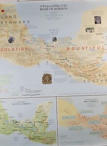
S$ 45.990 bidsS$ 28.77 shippingEnding Thursday at 4:47 SGT15h 54mBOOK OF MORMON "A Proposed Map" 1998 Travel Poster 26" X 28" MINT CONDITION
S$ 145.98S$ 119.27 shipping1912 Plat Map ~ LINCOLN Twp., DOUGLAS Co., MINNESOTA - ELLIS ~ Free S&H
S$ 45.990 bidsS$ 28.77 shippingEnding Thursday at 8:00 SGT19h 7mLarge Vintage Pickett County Tennessee Highway Map, RR, Bridges & Much More
S$ 17.69Was: S$ 22.12S$ 37.54 shippingLarge Vintage DECATUR County Tennessee Highway Map, RR, Bridges & Much More
S$ 17.69Was: S$ 22.12S$ 37.54 shippingNew ListingFayetteville West Virginia WV County Map 1976 Geological Topographical Survey
S$ 58.97S$ 36.05 shippingNew ListingWaterboro Maine York County Map Topographical Survey East Hollis Lyman Kennebunk
S$ 58.97S$ 36.05 shippingVintage 1986 WILKIN County, Minnesota Rural Resident Directory Plat Book
S$ 11.78S$ 44.47 shippingNew ListingMarcus Hook Delaware County Pennsylvania County Map Topographical Upp Chichester
S$ 58.97S$ 36.05 shipping1960-70 Historic Sites Map of Sonoma Valley 17.5x22.25 in.
S$ 16.15S$ 114.33 shippingVINTAGE ASBURY PARK, NEW JERSEY STREET MAP 18”x22” Wall Map MONMOUTH COUNTY, NJ
S$ 73.65S$ 43.79 shippingNew ListingLimington Maine York County Map Topographical Survey Standish Waterboro Hollis +
S$ 58.97S$ 36.05 shippingTexas Map - Hardeman County - Quanah Chillicothe Acme Goodlett Medicine Mound
S$ 14.73Was: S$ 18.42S$ 29.48 shippingNew ListingJones Alabama Autauga Dallas County Old Map Topographical Survey Mulberry Creek
S$ 58.97S$ 36.05 shippingNew Listing1938 Map of Winchester Wisconsin Quadrangle Geological Survey
S$ 51.61S$ 41.57 shippingVINTAGE LAND ATLAS & PLAT BOOK 2021 COUNTY CARLTON MINNESOTA ROCKFORD MAP
S$ 14.73S$ 46.99 shipping1929 Plat Map ~ CITY of PERU, LA SALLE, Co., IL / LOSTANT, RUTLAND on Reverse
S$ 63.68Was: S$ 67.75S$ 28.77 shippingOld (15x17) 1929 County / Plat Map ~ TAZEWELL COUNTY, ILLINOIS ~ Free S&H
S$ 67.75Was: S$ 72.07S$ 28.77 shippingLakeland Florida Map Polk County 1929 Mendenhall Original
S$ 73.71S$ 45.71 shipping1980 Soil Survey of Dodge County Wisconsin Book / Maps
S$ 51.61S$ 76.67 shippingVintage 1983 NOBLES ROCK County, Minnesota Rural Resident Directory Plat Book
S$ 8.83S$ 44.38 shipping1974 Zoning Map Of Ketchum Blaine County OldPaperMaps
S$ 44.22S$ 35.62 shippingVintage “A GRAPHIC HISTORY OF DELAWARE COUNTY” Map Lay Out Of 4 Centuries R
S$ 66.35S$ 36.27 shippingVintage AAA Automobile Club of Southern California Pouch w 4 dual state maps
S$ 44.22S$ 35.62 shipping