Vintage Original Antique Maps, Atlases & Globes
115 Results
Vintage Replogle World Globe Nation Series 12 Inch Diameter Raised Map Tilt
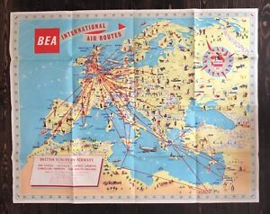
S$ 52.31S$ 357.09 shippingBEA BRITISH EUROPEAN AIRWAYS ORIGINAL VINTAGE ROUTE MAP AIRLINE POSTER 1958
S$ 851.89S$ 25.47 shippingBartholomew's Revised "Half-Inch" Contoured Maps Great Britain, 39 Tyneside
S$ 10.76S$ 40.40 shippingBartholomew's Revised "Half-Inch" Contoured Maps Great Britain, 45 Mid-Scotland
S$ 10.76S$ 40.40 shippingOriginal 1936 Map The British Somaliland - Ethiopia Boundary 9in x 9.5
S$ 37.56S$ 11.83 shipping1931 map Langia Acholi Mountain Anglo- Egyptian Sudan Uganda Border 13in x 1
S$ 50.09S$ 13.30 shippingVtg Replogle World Globe Classic Series 12 Inch Raised Map Henkel Wooden stand
S$ 109.47S$ 612.78 shipping1911 MAP LABRADOR PENINSULA. By Dr. WIlfred T. Grenfell 11in x 1
S$ 62.62Free postage1901 MAP GREAT BEAR Lake to Slave Lake Canada by J Macintosh Bell 12in x 1
S$ 62.62Free postageVintage 1959 Canada Department Of Mines And Technical Surveys Map
S$ 16.16S$ 10.77 shipping1880 Map Expedition East Africa LAKE NYASSA & TANGANYIKA 20in x 9.2
S$ 50.09S$ 13.30 shippingCALAIS FRANCE VINTAGE ORIGINAL AVIATION MAP 1930
S$ 185.64S$ 25.91 shippingVintage National Geographic World Globe With Acrylic Cradle 1962 Mid Century
S$ 102.28S$ 506.14 shippingBartholomew's Revised "Half-Inch" Contoured Maps Great Britain 18 Vale Of Severn
S$ 10.76S$ 40.40 shippingBartholomew's Revised "Half-Inch" Contoured Maps Great Britain, 24 Vale Of Trent
S$ 10.76S$ 40.40 shippingBartholomew's Revised "Half-Inch" Contoured Maps Great Britain, 52 Deeside
S$ 9.68S$ 40.40 shippingVINTAGE GLOBE Atlas Map 12" 1970s IN FRENCH EN FRANCAIS Metal Art Deco REPLOGLE
S$ 75.39S$ 550.55 shippingOriginal 1896 Map of Central Siam 10in x 1
S$ 37.56S$ 13.30 shippingVintage Map of PUNJAB PROPORTION BORNE BY BRAHMAN CASTE 1890'S 8in x 6.5
S$ 37.56S$ 14.78 shipping1911 NORTHERN PART PURCELL RANGE Canada. From Provincial Mining Maps 10in x
S$ 62.62Free postage1931 Map Norwegian Expeditions Antarctic Regions. Olaf Holtedal 16in x 13.5
S$ 37.56S$ 13.30 shipping1911 MAP BRITISH COLUMBIA Selkirk Range MOUNT SIR SANDFORD - H Palmer 13in x
S$ 62.62Free postage1961 Map UNION TERRITORY DELHI - POPULATION SPEAKING HINDI LANGUAGE 11inx 8.5
S$ 18.78S$ 11.83 shippingVintage Replogle Stereo Relief Globe
S$ 188.51Original 1936 Map Alaska. Lituya Bay and Mount Crillon District. 15in x 9.5
S$ 37.56S$ 11.83 shippingIndia Vintage Map CENSUS DIVISIONS OF DELHI MUNICIPALITY 1890'S 8in x 12.5
S$ 62.62S$ 14.78 shippingMap India - DISTRIBUTION OF MAJOR RELIGIONS in 1901 12in x 1
S$ 18.78S$ 11.83 shipping1880 Map ESTANCIA DE SAN JORGE URUGUAY. Frugoni 10.50in x 9.2
S$ 50.09S$ 13.30 shippingBartholomew's Revised "Half-Inch" Contoured Maps Great Britain, 35 Teesdale
S$ 10.76S$ 40.40 shippingBartholomew's Revised "Half-Inch" Contoured Maps Great Britain, 55 Moray Firth
S$ 10.76S$ 40.40 shippingBartholomew's Revised "Half-Inch" Contoured Maps Great Britain, 23 N. Shropshire
S$ 10.76S$ 40.40 shippingBartholomew's Revised "Half-Inch" Contoured Maps Great Britain, 19 Warwickshire
S$ 10.76S$ 40.40 shipping1936 Map ELLESMERE ISLAND EXPEDITION 7in x 9.5
S$ 37.56S$ 11.83 shipping1936 Original Map Southampton Island Canada. T.H Manning 13in x 12.5
S$ 37.56S$ 11.83 shippingOriginal 1904 Map District Quetta Pishin Afghanistan 16.50in x 1
S$ 100.20S$ 13.30 shippingMap India - DISTRIBUTION OF MAJOR RELIGIONS 1951 & 1961 12in x 1
S$ 18.78S$ 11.83 shipping1901 MAP ZEILA TO LAKE STEFANIE. NORTH EAST AFRICA. James J Harisson 24in x 2
S$ 62.62Free postageVintage National Geographic Inflatable World Globes 1985 Set Of 2 Educational
S$ 32.26S$ 70.23 shippingBartholomew's Revised "Half-Inch" Contoured Maps Great Britain, 58 Cape Wrath
S$ 10.76S$ 40.40 shippingBartholomew's Revised "Half-Inch" Contoured Maps Great Britain, 40 Ayrshire
S$ 10.76S$ 40.40 shipping*RARE VINTAGE (UNITED KINGDOM) "AUSTRALIA- DAINTY TALES OF EMPIRE LANDS" COLOUR
S$ 18.31S$ 6.46 shipping1915 MAP Bolivia Brazil Boundary Region Tacna Beni Mamore 19.50in x 1
S$ 62.62Free postageCOLD WAR ERA CRAM'S IMPERIAL WORLD GLOBE WITH WOODEN BASE
S$ 401.07S$ 161.43 shipping1880 Map of Russian Lapland 11.50in x 14.5
S$ 62.62S$ 13.30 shipping1902 MAP Survey from HANKAU To CANTON. By W. Barclay Parsons 20in x 2
S$ 62.62Free postageVTG 1948 North Germany Tourist Map After WWII Colorful Photo
S$ 14.810 bidsEnding 22 May at 10:07 SGT5d 11hS$ 6.45 shippingIndia Vintage Map showing CENSUS DIVISIONS OF LAHORE MUNICIPALITY 8in x 12.5
S$ 37.56S$ 14.78 shipping1902 ROUTE MAP from FARAFRA TO SIWA. By Wilfred Jennings Bramly. 12in x 1
S$ 62.62Free postage1934 Map of The Colony and Protectorate of Nigeria. 19.50in x 16.5
S$ 37.56S$ 13.30 shipping1941 - PROVINCE OF QUEBEC (CANADA) - HIGHWAY AND TOURIST - MAP - ORIGINAL
S$ 32.32S$ 53.85 shipping1902 MAP Route From Mogador to Marrakesh by Fawcett 10in x 1
S$ 62.62Free postage1911 MAP DUTCH NEW GUINEA Expeditions of H.A. LORENTZ 14in x 1
S$ 62.62Free postage1901- 1961 Map UNION TERRITORY of DELHI - Progress of Urbanization 11in x 8.5
S$ 18.78S$ 11.83 shipping1939 Map The Gold Coast. With Togoland Under British Mandate 13.50in x 21.2
S$ 37.56S$ 13.30 shipping1961 Map UNION TERRITORY OF DELHI - FORESTS 11in x 8.5
S$ 18.78S$ 11.83 shipping1960's New Alignments of China Traditional Frontiers map 13.75in x 1
S$ 18.78S$ 11.83 shippingVintage Map of The Minbu Anticline 11in x 4
S$ 37.56S$ 13.30 shippingVintage Map Ramri Island, Arakan. 11in x 1
S$ 37.56S$ 13.30 shipping1902 Map PERSIA AFGHANISTAN BALUCHISTAN Journey's Major Sykes 20in x 17.5
S$ 250.52Free postage1910's India Map of LAHORE & ENVIRONS . IMPERIAL GAZETTEER ATLAS 10.25in x 8
S$ 125.25S$ 14.78 shipping