England Kent Antique Europe Maps & Atlases 1800-1899 Date Range
110 Results
antique Tombleson's map of river Thames with 9 inset views 1850 art print poster
S$ 53.84S$ 33.96 shipping20 watchingRiver Thames antique Victorian excursions guide map Eton to Nore 1849 art poster
S$ 35.46S$ 33.96 shipping9 watchingAntique Victorian Bennet's map river Thames Up down the River art print poster
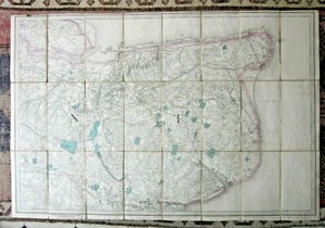
S$ 38.46S$ 33.96 shipping25 watching1863 Kent Original Antique Hand Coloured Weekly Dispatch Map
S$ 37.50S$ 20.64 shippingKENT, HURST GREEN, BATTLE, HASTINGS, original antique road map, MOGG, 1817
S$ 65.66S$ 17.82 shipping1825 ANTIQUE PLAN MAP - 1667 BATTLE RAID ON MEDWAY - ANGLO-DUTCH WAR
S$ 85.97S$ 53.13 shippingKENT, MONKTON, RAMSGATE, TUNBRIDGE WELLS, original antique road map, MOGG, 1817
S$ 65.66S$ 17.82 shippingc1835 Maidstone Sandwich Deal Kent Map Town Plan Creighton Lewis Handcoloured
S$ 18.74S$ 13.13 shippingc1895 county Map of Kent England antique vintage Britannica 9th
S$ 9.38S$ 23.45 shippingKENT, Pinnock, white on black original antique map 1834
S$ 37.52S$ 17.82 shippingKENT MAIDSTONE BY WILLIAM MUDGE c1819 GENUINE 1st EDITION ORDNANCE SURVEY MAP
S$ 272.04S$ 15.01 shippingISLE OF THANET KENT MARGATE RAMSGATE c1822 BY EDWARD MOGG GENUINE ANTIQUE MAP
S$ 65.65S$ 15.01 shipping1885 Kent Original Hand Coloured Antique Map by G.W. Bacon
S$ 37.50S$ 20.64 shippingantique Tombleson's Panoramic map of river Thames & Medway 1850 art print poster
S$ 53.84S$ 33.96 shipping109 watchingVINTAGE ADMIRALTY CHART. No.2451. OWERS to DUNGENESS. 1920 Edition.
S$ 84.34S$ 38.97 shippingcirca 1880s map of kent ! ( adam & charles black )
S$ 27.52S$ 35.92 shippingAntique map of Kent by Henry Teesdale 1829
S$ 84.42S$ 18.76 shippingAntique map of Kent by Thomas Moules 1842
S$ 25.82S$ 35.84 shippingc1835 County Map Kent Lewis Topographical Dictionary Creighton Walker Antique
S$ 18.74S$ 11.26 shippingTHOMAS MOULE ORIGINAL HAND COLOURED ANTIQUE MAP OF KENT- CIRCA 1850
S$ 112.57S$ 28.14 shippingKENT ROMNEY MARSH BY WILLIAM MUDGE c1816 GENUINE 1st EDITION ORDNANCE SURVEY MAP
S$ 103.19S$ 15.01 shippingOriginal Antiquarian Framed Map of Kent c1845 - Dugdale - J Archer Gold
S$ 22.36S$ 55.04 shippingKENT, CANTERBURY, DOVER, MAIDSTONE, original antique map, Bacon, 1895
S$ 33.77S$ 17.82 shipping1838 nice ORIGINAL MAP UNITED KINGDOM ENGLAND WALES LONDON CARDIFF MANCHESTER
S$ 56.81S$ 22.14 shippingFirst Series East Kent Ordnance Survey OS Map Canterbury Dover Railways Antique
S$ 103.19S$ 28.14 shipping1824. DEAL TO HYTHE AND HYTHE TO RYE. PATTERSON ROAD MAPS.
S$ 32.70S$ 49.91 shippingEdward Weller South Eastern Railway Map (c1860) Dover & Hastings Branch, Kent
S$ 46.88S$ 22.42 shippingKENT CANTERBURY BY WILLIAM MUDGE c1819 GENUINE 1st EDITION ORDNANCE SURVEY MAP
S$ 328.32S$ 15.01 shipping1823 A. M. Perrot Antique Map, Essex, Kent, England
S$ 77.88S$ 19.47 shippingROCHESTER, KENT, UK, Street Plan, Dawson Original antique map 1832
S$ 90.05S$ 17.82 shippingSANDWICH, KENT, Street Plan, Dawson Original antique map 1832
S$ 65.66S$ 17.82 shippingOriginal Antique Victorian Map of Dover - Published 1891
S$ 51.62S$ 50.12 shippingENGLAND V. South East, Wiltshire to Kent, original antique map, SDUK, 1844
S$ 46.90S$ 17.82 shippingDover Castle Key To England Kent England Steel Engraving From 1875
S$ 14.18S$ 6.72 shippingAntique map of Kent by William Lewis 1819
S$ 28.14S$ 9.38 shippingKENT, original antique map, RAILWAYS, Sidney Hall, c.1848
S$ 30.96S$ 17.82 shippingKENT, PEMBURY, LAMBERHURST, FLIMWELL, original antique road map, MOGG, 1817
S$ 65.66S$ 17.82 shippingmap Kent by John Aikin England Delineated Original with text c1803
S$ 58.44S$ 16.79 shippingKENT original antique county map, Reform Bill, W. Ebden, J. Duncan, 1838
S$ 93.81S$ 17.82 shippingDover Region of England - Original 1898 Map by J. Bartholomew, Antique
S$ 32.47S$ 45.10 shippingKENT, RIVERHEAD, SEVENOAKS, TUNBRIDGE, original antique road map, MOGG, 1817
S$ 65.66S$ 17.82 shippingKENT, STURRY, MONKTON, ACOL, MARGATE, original antique road map, MOGG, 1817
S$ 65.66S$ 17.82 shipping1841 Antique Map; Kent by Thomas Moule
S$ 37.50S$ 9.76 shippingc1850 Wyld Kent Reduced Ordnance Survey Faden Mudge Large 96x65cms Antique Map
S$ 328.32S$ 41.27 shipping1829 Greenwood Kent Genuine Antique Map Large 75x64cms Canterbury Cathedral RARE
S$ 234.51S$ 46.90 shippingVintage Copy Antique 19th Century Map of Kent by Wrightsons Foilgraphics London
S$ 17.21S$ 46.56 shipping1841 Antique Map; Isle of Thanet, Kent by Thomas Moule
S$ 37.50S$ 9.76 shippingCANTERBURY, KENT England City & Street Plan, Dawson Original antique map 1832
S$ 75.04S$ 17.82 shippingFOLKESTONE, KENT England Town & Street Plan, Dawson Original antique map 1832
S$ 46.90S$ 17.82 shippingDover Castle Key To England Kent England Steel Engraving From 1875
S$ 17.28S$ 7.12 shippingESSEX, KENT, original antique miniature county map, Perrot, 1828
S$ 65.66S$ 17.82 shipping1832 Canterbury Map Town Plan Kent Dawson Reform Act Boundaries Old Antique
S$ 37.50S$ 33.77 shippingVictorian Edward Stanford New 1 Inch Ordnance Survey Cloth Map Sheet 271 Kent
S$ 25.80S$ 33.22 shippingOriginal antique miniature county map KENT, Samuel Leigh, 1820-31
S$ 33.77S$ 17.82 shipping1839 Greenwood Select Map Kent Epitome History London Canterbury Antique SCARCE
S$ 159.47S$ 33.77 shippingMAIDSTONE,KENT, ENGLAND, Street Plan, Dawson Original antique map 1832
S$ 71.29S$ 17.82 shippingKENT original antique county map, LEWIS, CREIGHTON, WALKER, 1848
S$ 33.77S$ 17.82 shipping1812 Antique Map; Plan of Dover Harbour, Kent by John Farey
S$ 46.88S$ 9.76 shippingKent Antique Colour Map Thomas Moule County Maps of Old England 14“
S$ 25.80S$ 35.82 shippingTHE ENVIRONS OF LONDON, original antique atlas map, Bacon, 1895
S$ 37.52S$ 17.82 shipping