England Antique Original Antique European Atlases 1700-1799 Date Range
962 Results
1782 English Channel & West Coasts of France, Spain & Portugal Antique Map
S$ 64.64S$ 20.32 shipping1794 Country Around Manchester Large Folding Map by Stockdale 84 cm x 81 cm
S$ 323.19S$ 14.77 shipping1793 Plan Manchester & Salford Large Folding Map by Charles Laurent 106 cm x 91
S$ 593.02S$ 13.55 shippingAntique 1771 Map, Derby Shire, England, Plan of Grand Canal Trent to Hersey
S$ 140.20S$ 38.49 shippingROCHESTER ENGLAND 1738 NATHANIEL BUCK LARGE UNUSUAL ANTIQUE COPPER ENGRAVED VIEW
ANTIQUE COPPER ENGRAVED VIEW OF ROCHESTER ENGLAND 1738S$ 27.091 bidS$ 36.91 shippingEnding Tuesday at 13:09 SGT20h 39mAntique Sea Chart ENGLISH CHANNEL England & France G.Collins Nautical Map 1756
S$ 923.41S$ 31.35 shippingAntique map of Gloucestershire by Robert Morden 1715
S$ 83.11S$ 12.93 shippingMONMOUTH, CARDIFF, ABERAVON, BRITANNIA DEPICTA, original antique map, Bowen 1720
S$ 34.17S$ 17.54 shippingLONDON, CHELMSFORD, HARWICH, BRITANNIA DEPICTA original antique map, Bowen 1720
S$ 34.17S$ 17.54 shippingNORTHAMPTONSHIRE COUNTY MAP, BRITANNIA DEPICTA original antique map, Bowen, 1720
S$ 55.40S$ 17.54 shippingKENT, CANTERBURY, DOVER, BRITANNIA DEPICTA original antique map, Bowen 1720
S$ 34.17S$ 17.54 shippingTHOMAS KITCHIN -ANTIQUE HAND COLOUR MAP-A NEW MAP OF LINCOLNSHIRE-1764
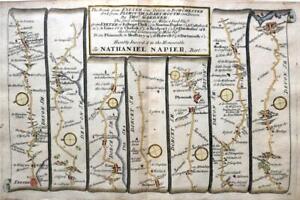
S$ 40.63S$ 27.70 shippingLONDON TO CHICHESTER WINCHESTER BY JOHN OGILBY REDUCED BY THOMAS GARDNER c1719
S$ 110.81S$ 14.77 shippingVintage framed Map and illustrations of Derbyshire England colored
S$ 125.51S$ 169.41 shipping1795 The Huddersfield Narrow Canal To Ashton Under Lyne Original Antique Map
S$ 36.92S$ 14.77 shipping1720 Abingdon - Fairford Gloucester - Monmouth Antique Road Map by Emanuel Bowen
S$ 33.22S$ 14.77 shipping1720 Bowen Road Map Lamberhurst Kent to Rye Sussex London Description Ogilby
S$ 46.15S$ 27.70 shippingROYSTON, HUNTINGDON, STILTON, STAMFORD, original antique road map, Bowen, 1720
S$ 34.17S$ 17.54 shippingmap of Norfolk by Bowen original copper engraved large antique map c1763
S$ 542.19S$ 13.39 shippingRUTLANDSHIRE RUTLAND BY ROBERT MORDEN c1727 GENUINE ANTIQUE ENGRAVED MAP
S$ 83.09S$ 14.77 shipping1840 ORIGINAL MAP GREAT BRITAIN IRELAND ENGLAND SCOTLAND WALES Dublin London
S$ 81.20S$ 23.63 shipping1681 (1715) Antique Map; Sussex by Richard Blome / Hollar
S$ 92.32S$ 9.60 shipping15 watchingLEICESTERSHIRE BY BADESLADE & TOMS c1742 ORIGINAL HAND COLOUR GENUINE ANTIQUE
S$ 73.85S$ 14.77 shippingDEVON CORNWALL LAUNCESTON BARNSTAPLE BY EMANUEL BOWEN GENUINE ANTIQUE c1720
S$ 55.39S$ 14.77 shipping1720 Bowen Kent & Essex Road Map Dover Canterbury Deal Chelmsford Maldon Ogilby
S$ 46.15S$ 22.16 shipping1795 West Yorkshire Original Antique Map by John Stockdale
S$ 46.15S$ 14.77 shippingESSEX CHELMSFORD BRENTWOOD SUFFOLK NORFOLK BY PATERSON c1785 GENUINE ANTIQUE MAP
S$ 27.68S$ 14.77 shipping1722 ROBERT MORDEN MAP OF NORFOLK - Norwich Yarmouth Blakeney Thetford Diss
S$ 135.530 bidsS$ 40.63 shippingEnding 20 May at 2:08 SGT6d 9h1795 The Huddersfield Narrow Canal To Ashton Under Lyne Antique Map
S$ 46.15S$ 14.77 shipping1794 Worcestshire Original Antique Map by Thomas Conder
S$ 36.94S$ 14.77 shipping1720 Tempsford - St Neots - Stilton - Peterborough Road Map by Emanuel Bowen
S$ 33.22S$ 14.77 shipping1795 Chester City Plan Original Antique Map by John Stockdale
S$ 92.32S$ 14.77 shippingCORNWALL DEVON ROAD MAP BY JOHN OGILBY REDUCED BY THOMAS GARDNER c1719
S$ 110.81S$ 14.77 shippingSUSSEX BRIGHTON CHICHESTER HASTINGS BY JOHN ROCQUE GENUINE ANTIQUE MAP c1769
S$ 92.32S$ 14.77 shippingGLOUCESTER CHELTENHAM MONMOUTH BRECON BY PATERSON c1785 GENUINE ANTIQUE MAP
S$ 36.92S$ 14.77 shippingCAMBRIDGESHIRE CAMBRIDGE BY EMANUEL BOWEN c1720 GENUINE ANTIQUE ENGRAVED MAP
S$ 73.85S$ 14.77 shippingLONDON TO HOLYHEAD ROAD MAP BY JOHN OGILBY REDUCED BY THOMAS GARDNER c1719
S$ 92.34S$ 14.77 shippingMITCHAM, SUTTON, BANSTEAD DOWNS, REIGATE, original antique road map, CARY, 1790
S$ 64.64S$ 17.54 shipping✨DEVONSHIRE Drawn from an ACTUAL SURVEY… By T. Kitchin Geog'r FRAME 26CM X 31CM✨
S$ 121.97Was: S$ 152.47S$ 65.81 shipping1795 Cheshire Original Antique Map by John Stockdale
S$ 46.15S$ 14.77 shippingHAMPSHIRE BY GEORGE BICKHAM c1754 BIRDS EYE VIEW PLUS 3 PAGES OF DESCRIPTION
S$ 465.94S$ 13.55 shippingLONDON TO BERWICK STILTON BY JOHN OGILBY REDUCED BY THOMAS GARDNER c1719
S$ 92.34S$ 14.77 shippingEXETER TO DORCHESTER ROAD MAP BY JOHN OGILBY REDUCED BY THOMAS GARDNER c1719
S$ 101.58S$ 14.77 shippingNORTHAMPTONSHIRE BY THOMAS KITCHIN GENUINE ANTIQUE COPPER ENGRAVED MAP c1769
S$ 73.85S$ 14.77 shippingSHROPSHIRE SALOP BY BADESLADE & TOMS c1742 GENUINE ANTIQUE ORIGINAL HAND COLOUR
S$ 73.85S$ 14.77 shippingLANCASHIRE PRESTON LANCASTER CUMBRIA BY PATERSON c1785 GENUINE ANTIQUE MAP
S$ 27.68S$ 14.77 shippingLONDON TO BERWICK YORK ROAD MAP BY JOHN OGILBY REDUCED BY THOMAS GARDNER c1719
S$ 92.34S$ 14.77 shippingROCHESTER, CHATHAM, LEWISHAM, ELTHAM, SIDCUP original antique road map CARY 1790
S$ 64.64S$ 17.54 shippingSHREWSBURY TO CHESTER & HOLYWELL BY JOHN OGILBY REDUCED BY THOMAS GARDNER c1719
S$ 83.11S$ 14.77 shippingAntique Map "A Map of the Countries Thirty Miles Round London" T. Kitchin, 1758
S$ 406.30S$ 33.24 shippingHUNTINGDONSHIRE HUNTINGDON BY JOHN ROCQUE c1769 GENUINE ANTIQUE ENGRAVED MAP
S$ 73.85S$ 14.77 shippingYORK TO WHITBY & SCARBOROUGH BY JOHN OGILBY REDUCED BY THOMAS GARDNER c1719
S$ 101.58S$ 14.77 shippingTUNBRIDGE, TUNBRIDGE WELLS, LONDON, original antique road map, CARY, 1790
S$ 73.87S$ 17.54 shippingDORKING, LEATHERHEAD, FETCHAM, EFFINGHAM, , original antique road map CARY, 1790
S$ 64.64S$ 17.54 shippingGLOUCESTER TO COVENTRY BY JOHN OGILBY REDUCED BY THOMAS GARDNER c1719
S$ 120.04S$ 14.77 shippingLANCASHIRE MANCHESTER CAMBRIDGE ELY BY PATERSON c1785 GENUINE ANTIQUE MAP
S$ 27.68S$ 14.77 shippingOXFORD TO SALISBURY & POOLE BY JOHN OGILBY REDUCED BY THOMAS GARDNER c1719
S$ 92.34S$ 14.77 shippingWILTSHIRE DORSET ROAD MAP BY JOHN OGILBY REDUCED BY THOMAS GARDNER c1719
S$ 101.58S$ 14.77 shipping1793 West Yorkshire Original Antique Map by John Cary Hand Coloured in Outline
S$ 46.15S$ 14.77 shipping1795 Lancashire Original Antique Map by John Stockdale
S$ 46.15S$ 14.77 shipping