Antique North American Maps Maine 1910-1919 Date Range Atlases
93 Results
Portland Harbor Maine City Plan & Coastal Survey c. 1910 nautical navigation map
S$ 364.91Was: S$ 405.46S$ 62.17 shippingKennebunk Maine Ogunquit Wells Beaches 1917 U.S. Geological Survey topo chart
S$ 99.52Was: S$ 110.58S$ 47.49 shippingBingham Quadrangle Somerset County Maine 1913 detailed topo chart
S$ 86.25Was: S$ 95.84S$ 90.72 shippingWaldoboro Maine Union Nobleboro Warren 1915 U.S. Geological Survey topo chart
S$ 112.79Was: S$ 125.32S$ 57.68 shipping1910's Roosevelt Midland Trail Road Map & Guide The Main Street of America
S$ 13.511 bidS$ 41.90 shippingEnding 13 May at 10:12 SGT4d 9h1915 Topographical Atlas Colored Map Of Maine 11" x 14"
S$ 33.17S$ 64.93 shippingUSA (NE) Maine, Vermont, Pennsylvania - Antique Map c1912 by W&AK Johnston
S$ 16.64S$ 18.49 shippingKezar Falls Maine 1910 Original Vintage USGS Topo Map R.B. Marshall 21"x17"
S$ 36.86S$ 41.49 shippingVintage 1912 Atlas Map ~ MAINE ~ Old & Authentic ~ Free S&H
S$ 30.49Was: S$ 32.44S$ 28.77 shipping1912 USGS topo map Swan Island Quadrangle Maine Long Island Bluehill Bay
S$ 145.96S$ 55.04 shipping1910 USGS topo map Mount Desert Quadrangle Maine Union River
S$ 145.96S$ 55.04 shipping1919 Auto Road Map Maine Portland Bangor Lewiston Augusta Bar Harbor Mt Desert
S$ 35.37Was: S$ 44.22S$ 29.47 shippingCENTURY ATLAS MAP PLATE #6 MAINE UNITED STATES ME USA 1911 ANTIQUE ORIGINAL
S$ 29.41S$ 27.20 shippingVassalboro Quadrangle Maine Windsor Augusta Winslow 1913 detailed topo chart
S$ 86.25Was: S$ 95.84S$ 90.72 shippingLewiston Maine Auburn Sabattus Monmouth 1912 detailed topo chart
S$ 86.25Was: S$ 95.84S$ 90.72 shippingBerwick Maine Rochester NH York Co. 1913 U.S. Geological Survey topo chart
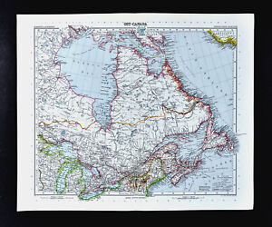
S$ 86.25Was: S$ 95.84S$ 47.11 shipping1911 Stieler Map Canada Ontario Quebec Nova Scotia Hudson Bay Great Lakes Maine
S$ 23.58Was: S$ 29.47S$ 29.47 shipping1911 Antique Rand McNally Map of MAINE w/copy History/Demographics
S$ 19.09S$ 37.79 shipping1912 Massachusetts Historical Society Facsimile of Johnston's 1754 Kennebec Maps
S$ 221.16S$ 50.63 shippingEastport, Maine Folio No. 192 Geologic Atlas of the United States, 1914
S$ 36.86S$ 104.19 shippingCENTURY ATLAS MAP PAGE PLATE NO.6 STATE OF MAINE 1911 VINTAGE
S$ 14.73S$ 44.56 shipping1914 TEXTILE WORLD RECORD SHOWING TEXTILE MILL TOWNS IN MAINE, VERMONT, NH.
S$ 10.31S$ 34.62 shipping1914 Map of Bagaduce River Maine, Channel to South Penobscot
S$ 73.72S$ 51.23 shipping1917 McNally Map - Maine Augusta Bangor Portland Rockland Belfast Dover Caribou
S$ 14.73Was: S$ 18.42S$ 29.47 shippingAntique Rand McNally indexed pocket Maine map book auto road railroad guide 1918
S$ 59.15S$ 27.20 shipping1918 USGS topo map Machias Quadrangle Maine Roque Bluff Cross Island Cutler
S$ 145.96S$ 55.04 shippingRare Vintage 1911 Atlas Map ~ MAINE - AUGUSTA ~ Old & Authentic ~ Free S&H
S$ 30.49Was: S$ 32.44S$ 28.77 shippingMAINE USGS Topo MAP CUTLER quad 1918 / 1920
S$ 14.73S$ 44.70 shipping1911 antique map - maine
S$ 33.94S$ 35.79 shipping1911 Stieler Map - United States New York City Boston Massachusetts Maine Jersey
S$ 47.17Was: S$ 58.96S$ 29.47 shipping1917 Poates Map - Maine - Portland Augusta Bangor Rockland Caribou Eastport ME
S$ 14.73Was: S$ 18.42S$ 29.47 shippingTHE OFFICIAL MAP OF MAINE The National Survey Co. 1914
S$ 29.49S$ 45.13 shippingVintage Hammonds 1911 Atlas Map Of The United States And Maine
S$ 10.25S$ 50.50 shipping1910 Rand-McNally Antique Map///MAINE, b/w UNITED STATES
S$ 29.47S$ 35.18 shippingAntique Color Map 1913 United States of America or State of Maine
S$ 13.20S$ 37.70 shippingAntique 1904 Topography Map Castine, Maine Penobscot Bay Quadrangle
S$ 81.09S$ 51.44 shipping1915 Geological Survey Map Maine Topography Waldoboro Quadrangle 20 x 16.5
S$ 110.58S$ 60.04 shipping1913 Maine Wall Map post office routes postal mail canvas backed 48.5 x 38.5"
S$ 112.04Was: S$ 140.05S$ 129.54 shipping1914 U.s. Geological Survey Topography Map Maine Bucksport Quadrangle 20 x 16.5
S$ 73.72S$ 58.96 shipping1914 Geological Survey Topography Map State Maine Penobscot County, Orono Quadra
S$ 147.44S$ 57.22 shippingU.s. Geological Survey Map Topography State Of Maine Belfast Quadrangle 1917
S$ 110.58S$ 50.25 shipping1914 Vintage Map "Maine" or "Louisiana" Color Original From Collier Atlas
S$ 26.19S$ 52.18 shipping1917 MAINE And LOUISIANA Map By L. L. Poates Eng. Co.
S$ 16.20S$ 42.15 shipping1914 PORTLAND, MAINE, FERRY VILLAGE, FORT PREBLE, WILLARD SQUARE ATLAS MAP
S$ 73.65S$ 77.33 shippingAuthentic 1910 Plate Map ~ Great State of MAINE ~ Detailed ~ Extremely Rare
S$ 44.23S$ 43.51 shippingUnited States & Maine Original Antique 1918 Double Sided Hammond Engraved Maps
S$ 13.20S$ 44.95 shipping1910 Original Map Of Town Of Farmington Maine By H. E. Mitchell With Names
S$ 33.90S$ 35.31 shippingState Of Maine 1918 Topography Map, Knox County 20 x 16.5 u.s. geological Survey
S$ 147.44S$ 47.43 shipping1913 topography map small Point sheet Maine 20x16.5 , Casco Bay, phippsburg
S$ 51.60S$ 45.78 shippingExamination of Carvers Harbor, Vinalhaven, Maine, 1912 - Includes Map
S$ 66.35S$ 51.01 shippingANTIQUE 1911 UNITED STATES & MAINE DATED MAP TEXAS CALIFORNIA FLORIDA RAILROAD
S$ 11.78Was: S$ 14.73S$ 40.04 shipping1914 DOWNTOWN PORTLAND, MAINE OLD PORT CITY HALL & COURT HOUSE PLAT ATLAS MAP
S$ 73.65S$ 77.33 shippingORIG 1914 PORTLAND, MAINE GREAT & LITTLE DIAMOND ISLANDS FORT McKINLEY ATLAS MAP
S$ 221.08S$ 81.68 shippingVINTAGE 2-SIDED COLOR MAP -- NEW HAMPSHIRE & MAINE - c. 1907 By Rand McNally
S$ 19.09S$ 45.12 shipping1911 Collier Map of LOUISIANA, b/w MAINE
S$ 22.10S$ 44.75 shippingORIGINAL 1914 PORTLAND LIBBYTOWN UNION STATION MAINE GENERAL HOSPITAL ATLAS MAP
S$ 221.08S$ 81.68 shipping1914 PORTLAND MAINE BAYSIDE OAKDALE DEERINGS OAKS LINCOLN-CUMBERLAND ATLAS MAP
S$ 73.65S$ 77.33 shippingORIGINAL 1914 PORTLAND, MAINE, DEERING CENTER, LIBBYTOWN, CAPISIC POND ATLAS MAP
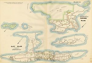
S$ 221.08S$ 81.68 shipping1914 PORTLAND, MAINE CLIFF ISLAND, FORTS LEVETT, GORGES & SCAMMEL COPY ATLAS MAP
S$ 73.65S$ 77.33 shipping9 watching1910 MAP ~ UNITED STATES NORTH AMERICA NORTH EASTERN NEW YORK OHIO MAINE GEORGIA
S$ 81.43Was: S$ 162.86S$ 27.76 shipping